Visit Bamiyan Afghanistan
Where colossal Buddha niches guard a valley of turquoise lakes, red fortresses and ancient cave paintings — Afghanistan's most extraordinary province awaits the curious traveler.
Where colossal Buddha niches guard a valley of turquoise lakes, red fortresses and ancient cave paintings — Afghanistan's most extraordinary province awaits the curious traveler.
In short (TL;DR)
Bamiyan sits in Afghanistan's central highlands at about 2,500 metres and is the country's most celebrated cultural landscape. The giant Buddha niches, the turquoise lakes of Band-e-Amir, Shahr-e-Zohak (the Red City), and Hazara hospitality are the main draws. The best time to visit Bamiyan is May to October. Go Kabul runs guided trips with flights, transport, and vetted stays.
Bamiyan at a glance — Quick Facts
Last updated: July 2026
Bamiyan province sits at the heart of the Afghan highlands, cradled by the western spur of the Hindu Kush mountains at roughly 2,500 metres above sea level. For millennia it served as a key waypoint on the Silk Road, linking the trading empires of China and Rome through a valley so fertile and strategically placed that monks, merchants, soldiers and artists all left their mark on its sandstone cliffs. Today, Bamiyan tourism is growing as travelers discover one of Central Asia's most compelling cultural landscapes.
The province is the traditional homeland of the Hazara people, whose warm hospitality, distinctive Dari dialect and rich oral traditions give Bamiyan a cultural texture unlike anywhere else in Afghanistan. Hazara communities have preserved centuries of folk music, embroidery and cuisine, and visitors are regularly invited to share meals of ashak dumplings, bolani flatbread and freshly churned doogh yogurt drink in family homes.
In 2003 the cultural landscape and archaeological remains of the Bamiyan Valley were inscribed on the UNESCO World Heritage List — and simultaneously placed on the List of World Heritage in Danger. International conservation teams continue to work on stabilising the cliff face and documenting the hundreds of caves, murals and monastic cells that honeycomb the sandstone escarpment. A visit to Bamiyan is therefore not just a holiday but a chance to witness living heritage conservation in action.
The climate is continental and dry. Summers are pleasantly warm — daytime temperatures hover around 25 °C in July — while winters bring heavy snow and sub-zero nights that close mountain passes. The altitude means UV radiation is strong; sunscreen and a hat are essential year-round. Despite the elevation, the valley floor is remarkably green from May to September, irrigated by snowmelt channelled through ancient karez underground waterways.
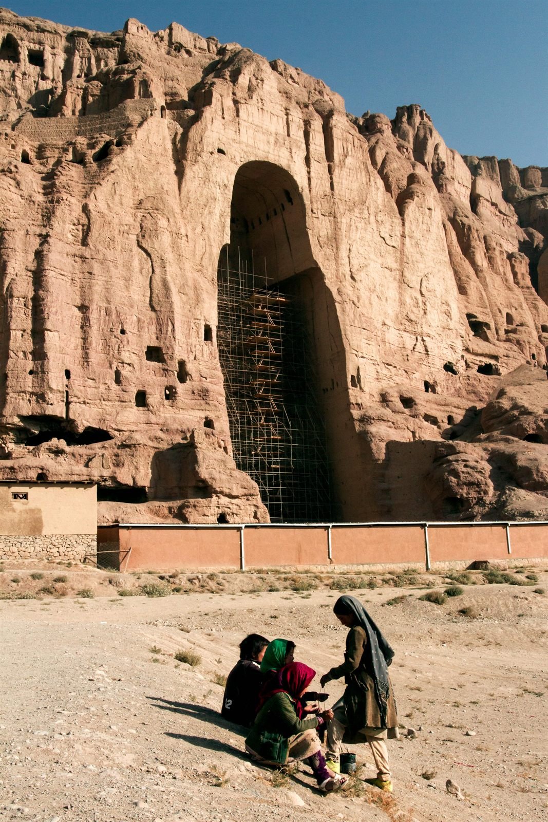
The Bamiyan Buddha statues — or, more accurately, the niches that once held them — are the single most iconic sight in Afghanistan. Carved directly into the northern cliff face of the Bamiyan Valley during the 6th century CE, the two standing Buddhas measured 55 metres and 38 metres tall respectively, making them the largest standing Buddha figures in the world at the time of their creation. They were surrounded by elaborately painted caves that functioned as a vast Buddhist monastery complex housing perhaps a thousand monks.
The statues were destroyed in March 2001, but the enormous niches remain deeply impressive. Standing at the base of the 55-metre niche, you crane your neck upward through a cathedral-like void and can still trace the carved folds of the missing robe in the surrounding rock. Fragments of the original Gandhara-style plaster work cling to the upper walls, and conservation scaffolding gives a sense of the ongoing international effort to preserve what survives.
Visiting the Buddha Niches is straightforward. The cliff face runs for roughly 1.3 kilometres along the northern edge of Bamiyan town, with the two main niches connected by a network of stairways and tunnels cut into the rock. A local guide is essential — not only for safety on the narrow interior staircases but also to point out the ceiling paintings, hidden meditation cells and graffiti left by travellers across a dozen centuries. Allow at least two to three hours for a thorough visit, preferably in the morning when the eastern light illuminates the cliff face.
International proposals to reconstruct the Buddhas have been debated for years. UNESCO currently maintains a policy of non-reconstruction, prioritising stabilisation of the niches and the surrounding cave paintings. Whether or not the statues are ever rebuilt, the empty niches carry a powerful resonance — a monument to both creation and loss that is unlike anything else on earth.
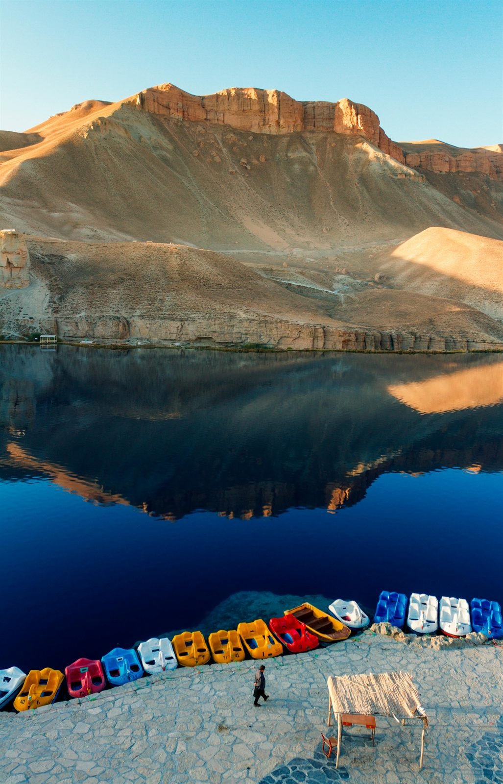
Approximately 75 kilometres west of Bamiyan town, at an elevation of nearly 2,900 metres, six extraordinary turquoise lakes sit in a chain along a barren limestone canyon. These are the Band-e-Amir lakes — Afghanistan's first national park, established in 2009 — and they are among the most visually striking natural wonders in all of Central Asia.
The lakes owe their vivid colour to dissolved carbon dioxide and calcium carbonate. Over thousands of years, mineral-rich water has deposited natural travertine dams — some reaching 10 metres high — that partition the river into a series of deep, intensely blue-green pools. The largest lake, Band-e-Haibat (Lake of Awe), stretches for roughly 6.5 kilometres. Others in the chain include Band-e-Zulfiqar, Band-e-Pudina, Band-e-Panir, Band-e-Gholaman and Band-e-Qambar.
Hiking around the lakes is the primary activity. A well-trodden trail follows the southern rim of the canyon, offering dramatic overlooks at each dam. The full circuit takes four to six hours at a comfortable pace. Swimming is possible in summer — locals paddle in the shallows of Band-e-Haibat — but the water is cold, typically 12–15 °C even in July. Picnicking on the grassy banks is popular with Afghan families, and small tea houses near the park entrance sell kebabs and fresh naan bread.
The best time to visit Band-e-Amir is from late May through September. By October the road becomes unpredictable and snow can close the passes. The drive from Bamiyan takes roughly two hours on an unpaved but well-maintained road, and most tour operators include a full-day excursion as standard. Camping is permitted near the park entrance, and a simple guesthouse offers basic overnight accommodation for those wanting a sunrise over the lakes.
About 15 kilometres east of Bamiyan town, at the strategic confluence of the Bamiyan and Kalu rivers, the ruins of Shahr-e-Zohak cling to a narrow ridge of deep-red rock. Known locally as the Red City, this fortified citadel dates back to the 6th century and served as the primary defensive position guarding the eastern approach to the Bamiyan Valley throughout the Kushan, Hephthalite and Ghorid periods.
The fortress earned its most dramatic chapter during the Mongol invasion of 1221. Legend holds that Genghis Khan's grandson was killed by an arrow fired from the walls of Shahr-e-Zohak, prompting the Great Khan to raze the fortress and the entire Bamiyan Valley in retribution. The scarred, oxidised-red walls you see today are largely the remains of that destruction, frozen in time by the dry mountain climate.
Reaching the citadel involves a moderately strenuous hike of roughly 45 minutes from the road. The trail switchbacks up through crumbling mud-brick walls and watchtowers, eventually arriving at a narrow summit with panoramic views of both river valleys. Bring sturdy footwear — the path is loose shale and sun-baked clay. A guide will point out cisterns, garrison rooms and the remains of a small mosque that once served the fortress garrison.
Roughly 10 kilometres west of Bamiyan town, the road passes through a narrow gorge where deep, sinuous fissures crack the cliff face in a pattern that, with a little imagination, resembles the body of a colossal dragon. This is Dara-e-Ajdahar — Dragon Valley — and the local legend is irresistible: a fearsome dragon once terrorised the valley until the Caliph Ali, son-in-law of the Prophet, struck it down with his legendary sword, Zulfiqar. The dragon's fossilised body, the story goes, became the fractured rock you see today.
Geologists offer a less mythological explanation: the fissures are the result of tectonic stress on folded limestone strata, widened over millennia by freeze-thaw cycles at high altitude. Either way, the formation is visually spectacular and makes for excellent photography. The site is easily visited as a stop on the drive to or from Band-e-Amir, and a short trail leads from a parking area to the base of the main fissure. Allow 30 to 45 minutes for a visit.
The sandstone cliffs surrounding Bamiyan are honeycombed with hundreds of man-made caves. Many of these were carved between the 3rd and 9th centuries as monastic cells, meditation chambers and assembly halls for the Buddhist community that flourished along the Silk Road. The interiors of several caves retain extraordinary wall and ceiling paintings executed in oil and tempera — some scholars believe these include the world's earliest known oil paintings, predating European use of the medium by several centuries.
The most accessible painted caves are found in the cliff face immediately surrounding the two Buddha niches. The ceiling of the 55-metre niche once displayed a magnificent solar deity painted in lapis lazuli blue and cinnabar red; fragments of this composition survive and are visible with the aid of a torch. Further along the cliff, Caves E and F contain damaged but still discernible Buddhist iconography — bodhisattvas, lotus motifs and scenes of devotion rendered in a style that blends Gandharan, Sassanian and Central Asian artistic traditions.
Beyond the heritage caves, many cliff-side caverns remain inhabited. Hazara families displaced by conflict in other provinces have made homes in the rock shelters for generations. Some of these communities welcome visitors, offering tea and conversation. It is a poignant juxtaposition — 21st-century life unfolding inside architecture carved before the birth of Islam — and it underscores the layered, living quality of Bamiyan's cultural landscape.
May through October. July and August are warmest (20–25 °C). Avoid November to March — heavy snow closes roads and passes. Spring (April–May) brings wildflowers but also occasional rain.
Bamiyan town sits at 2,500 m; Band-e-Amir at 2,900 m. Most visitors adjust within a day. Drink plenty of water, avoid heavy exertion on arrival, and carry sunscreen for strong UV at elevation.
Bamiyan offers several guesthouses and small hotels ranging from basic to comfortable. The Silk Road Hotel and Bamiyan Eco Lodge are popular choices. Book in advance during peak season (July–August).
Domestic flights from Kabul to Bamiyan take roughly 45 minutes (subject to availability). The overland drive via the Hajigak or Shibar Pass takes 6–8 hours. All Go Kabul tours include transport arrangements.
Bring cash (Afghani or USD) — ATMs are unreliable. Mobile coverage exists in town but drops in rural areas. Wi-Fi is available at most guesthouses but can be slow.
Photography is welcome at all sites. Ask permission before photographing locals, especially women. Drone usage requires prior government approval — your guide can advise.
Ready to experience Bamiyan for yourself?
Our 7-day Kabul & Bamiyan tour covers every site on this page with expert local guides, domestic flights and comfortable accommodation included.
View Kabul & Bamiyan TourIs Bamiyan safe to visit?
Bamiyan is widely regarded as one of the calmer regions of Afghanistan and is a highlight of most guided itineraries. Go Kabul travels here with experienced Hazara and local guides, private vehicles, and vetted guesthouses. Conditions can change, so contact us for the latest security update before booking your trip.
What is there to see in Bamiyan?
Bamiyan's main sights are the two colossal Buddha niches carved into the cliff, the six turquoise lakes of Band-e-Amir National Park, the red ruins of Shahr-e-Zohak, Dragon Valley, and hundreds of painted caves. Most travellers spend three to five days exploring the valley and its national park.
How do I get to Bamiyan?
Bamiyan is reached from Kabul either by a 45-minute domestic flight or a scenic six to eight hour drive over the Hajigak or Shibar Pass. There is no rail service. Go Kabul arranges flights or private 4x4 transport, plus all guides and accommodation, as part of every Bamiyan itinerary.
When is the best time to visit Bamiyan?
The best time to visit Bamiyan is May through October, when the passes are open and daytime temperatures are a comfortable 20 to 25 degrees Celsius. Avoid November to March, when heavy snow closes mountain roads. Bring sun protection year-round, as UV is strong at 2,500 metres.
Do I need a guide or permit for Bamiyan?
Foreign visitors travel to Bamiyan on guided tours rather than independently. A local guide is essential for safe access to the Buddha niches' interior staircases and for cultural context. Go Kabul handles all guides, permits, and logistics, including the Band-e-Amir National Park excursion.
Continue planning your central-highlands trip with these related destinations, tours, and travel guides.
Expert guides. Safe logistics. Authentic Afghan hospitality. Your Bamiyan journey starts with a single message.